Katja Gunia, Jo Van Brusselen, Risto Päivinen, Sergey Zudin, Elena Zudina
The main aim of the project targets at utilising most effectively both Earth Observation data and recent forest statistical information. It applies a previously developed calibration method to produce a comprehensive and complete European map on forest area at 1 x 1 kilometre resolution.
Data sources
Earth observation data:
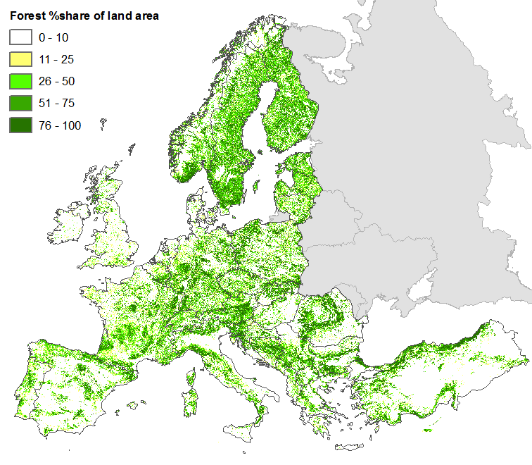
EU27, AL, BA, CH, HR, ME, MK, NO, RS, TR: Forest/non-forest map 2006 (beta version) prepared by the EC Joint Research Centre, aggregated to 1km resolution. Based on IRS-P6 LISS-III, SPOT4 (HRVIR) and SPOT5 HRG satellite data of 2006 (Figure 1, Kempeneers et al. 2011)
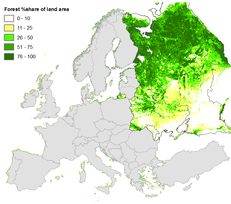
Belarus, Moldova, Ukraine, Russian Federation: Forest share estimates based on AVHRR NOAA satellite data of 1996-1998 (Figure 2, Schuck et al. 2002, Päivinen et al. 2001)
Statistical data:
National forest inventory statistics (Table 1)
State of Europe's Forests country statistics 2011 (PDF file)
Method
Combination of different data sources
Earth Observation data are regarded as a cost-efficient means for locating different types of vegetation cover at the ground level. Two different earth-observation products (Kempeneers et al. 2011 and Schuck et al. 2002 / Päivinen et al. 2001) have been combined with statistical data to produce a new pan-European forest map at 1km resolution that corresponds to the official forest inventory statistics at national and/or regional level. Besides geographical Europe, the map covers also Turkey.
The utilized forest/non-forest map of the EC Joint Research Centre (Kempeneers et al. 2011) is based on IRS and SPOT data and covers the EU27 countries + Norway, Switzerland, Turkey and the Balkan area. It was aggregated from 25m resolution to 1km by summing up the forest area for each 1x1km pixel (Figure 1). NOAA-AVHRR forest share estimates at 1km resolution (Schuck et al. 2002 / Päivinen et al. 2001, Figure 2) have been used to extend the map up to the Ural mountains, namely covering Belarus, Ukraine, Moldova, European part of the Russian Federation. The combined forest cover map shows the %share of forest in each 1x1km-pixel, but differs from official statistics which was tackled in the next step.
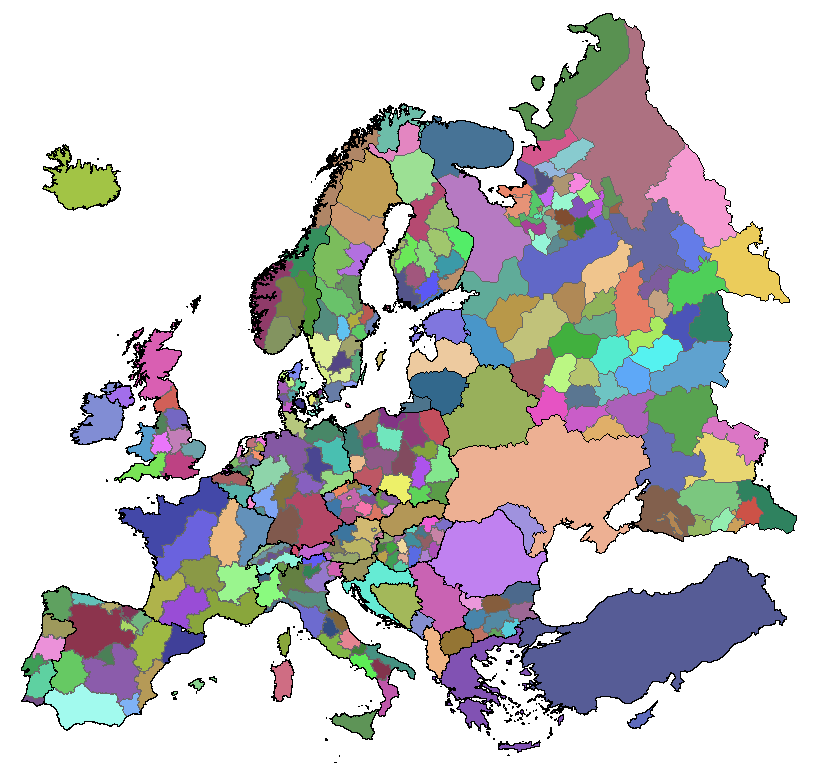
Statistical data on forest area and its distribution for different forest classes are traditionally available through national forest inventory statistics and other national and international forest statistical sources. Various sources of data were used to compile the map according to the availability of data: 1) Recent national forest inventory (NFI) statistics on forest area were used at the sub-national level for 19 European countries, including the European part of the Russian Federation (Table 1). 2) In addition, country-level statistics on forest area published by Forest Europe 2011 were applied for all countries covered by the map. Figure 3 demonstrates the spatial level of detail for the applied statistics.
| Country | Year of inventory | Reference |
|---|---|---|
| Austria | 2000-2002 | Bundesforschungs- und Ausbildungszentrum fuer Wald, Naturgefahren und Landschaft. Ergebnisse der Österreichischen Waldinventur 2000-2002. BFW Wien, Austria. http://web.bfw.ac.at/i7/oewi.oewi0002 |
| Belgium | 1994-2004 (Wallony), 1997-1999 (Flanders) | Wallony: Walloon Forest Inventory 1994-2004, http://environnement.wallonie.be/; Flanders: Waterinckx, M.; Roelandt, B. (2001). De bosinventarisatie van het vlaamse gewest : resultaten van de eerste inventarisatie 1997-1999. |
| Bulgaria | 2000 | EFISCEN database, http://www.efi.int/portal/virtual_library/databases/efiscen/inventory_database/ |
| Switzerland | 2004-2006 | WSL, Schweizerisches Landesforestinventar, LFI 3, 2004/2006 (Third Swiss forest inventory), http://www.lfi.ch/resultate/anleitung-en.php |
| Czech Republic | 2001-2004 | Results of the national forest inventory in the Czech Republic 2001 - 2004, http://www.uhul.cz/en/il/NIL_AJ.pdf |
| Germany | 2001-2002 | Zweite Deutsche Bundeswaldinventur (BWI 2). http://www.bundeswaldinventur.de |
| Denmark | 2000 | Skove og Plantager 2000. Denmark's Statistics, June 2002. http://www.dst.dk/publikation.aspx?cid=3132 |
| Spain | 1997-2007 | Tercer Inventario Forestal Nacional 1997-2007. Ministerio de Medio Ambiente. http://www.mma.es/portal/secciones/biodiversidad/montes_politica_forestal/estadisticas_forestal/estructura_forestal_2007.htm |
| Finland | 2008 | Metsätilastollinen vuosikirja (Finnish Statistical Yearbook of Forestry). The Finnish Forest Research Institute, http://www.metla.fi/julkaisut/metsatilastollinenvsk/index-en.htm |
| France | 2005-2008 | Inventaire Forestier National 2005-2008. http://www.ifn.fr/spip |
| Hungary | 2006 | EFISCEN database, http://www.efi.int/portal/virtual_library/databases/efiscen/inventory_database/ |
| Italy | 2006 | Inventario Forestale Nazionale 2006. http://www.sian.it/inventarioforestale/jsp/home.jsp |
| Netherlands | 2001-2002 | MFV 2002. Dirkse, G.M., Daamen, W.P., Schoonderwoerd, H., Paasman, J.M., 2003. Meetnet functievervulling bos. Het Nederlandse bos 2001-2002. Rapport EC-LNV nr. 2003/231. Expertisecentrum LNV, Ministerie van landbouw, natuur en voedselkwaliteit, Ede. |
| Norway | 2004 | Skog & Landskap (Norwegian Forest and Landscape Institute): Forest inventory statistics, http://www.skogoglandskap.no/temaer/statistikk_fra_landsskogstakseringen |
| Poland | 2002 | Polish State Forest Service 2002 |
| Portugal | 1995-1998 | Inventário florestal nacional Portugal continental, 3. revisão, 1995-1998. Direccão-Geral das Florestas, Lisboa 2001. |
| Sweden | 2004-2008 | Skogsstatistisk årsbok 2009 (Swedish Statistical Yearbook of Forestry 2009), Skogsstyrelsen (Swedish Forest Agency), Jönköping 2009. |
| United Kingdom | 1990-2003 | National Inventory of Woodland and Trees, http://www.forestry.gov.uk/website/forestry.nsf/byunique/infd-86xc6c |
| Russian Federation | 1990-2005 | Federal Forestry Agency Moscow, official forest statistics for 2011 |
Table 1: Overview of applied national forest inventory statistics with data at sub-national level (administrative regions).
Calibration of the map to official forest inventory statistics
The satellite-based forest cover data was first calibrated to sum up to the forest area statistics within a given administrative region. The calibration iteratively adjusts the pixel values in a region to sum up with the statistics while keeping the forest share per pixel below the maximum possible limit of 100%. This is achieved by first determining the ratio between the forest area in the map and in the statistics for each region. All pixel values in the respective regions are then multiplied by this ratio. Finally all pixels exceeding a forest share of 100% after multiplication, are set back to a value of 100. This process is repeated until the difference between forest area in map and statistics falls below a specified threshold (0.05%).
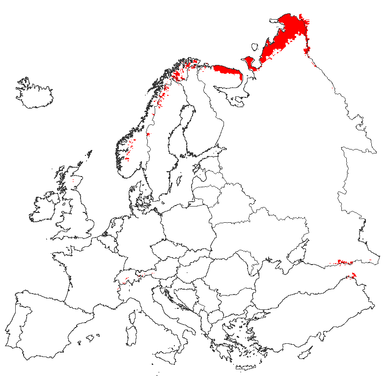
A European timberline mask compiled by Schuck et al. (2002) was implemented to exclude areas considered above the timberline from the calibration process (Figure 4). Such areas were automatically assigned a 0 value. In a first calibration run, the 19 countries with available NFI statistics (incl. Russian Federation) were adjusted to the values at the level of sub-national administrative regions. In a second run, all European countries (excl. Russian Federation) were adjusted to the internationally harmonized statistics by Forest Europe 2011 at national level, to allow for comparability between the countries. This second calibration slightly changed the results of the previous regional-level calibration if there were differences between NFI statistics and Forest Europe 2011 data. Still, the overall distribution of forest area between the different regions in a country (as stated in NFI statistics) remained the same also after the country-level calibration.
The calibration achieves an overall fit of the map with the statistics at regional and country level, i.e. when summing up all forest area in a country the result corresponds to the respective statistics. However, at the local level the map might differ from the real situation due to uncertainties in the applied remote sensing products and the changes introduced by the calibration procedure. Uncertainties are higher for Belarus, Ukraine, Moldova and Russia, since the input map used for these areas is of much lower resolution (1000m) than the one used for the rest of Europe (25m). For more background information on the quality of the input maps please refer to Kempeneer et al. (2011) and Schuck et al. (2002).
Results
An image of the final calibrated map is presented below.
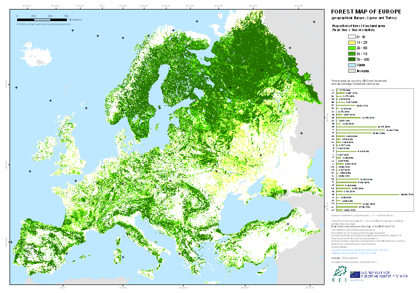
The map can be accessed free of charge after completing a simple registration process. Please go to the registration page if you would like to get access to the GIS layer and high resolution image of the forest map.
Note: There is an earlier version of the forest map available that includes maps on coniferous and broadleaved forest in Europe. These older maps (coniferous and broadleaved forest) can be accessed through the same link above. They are based on AVHRR-NOAA satellite data (1996-1998) and were calibrated to older statistics (TBFRA 2000 country statistics, national forest inventory statistics). The EFI Technical Report No. 13 describes methodological aspects ( download here). The coniferous and broadleaved forest maps do not include Cyprus and Turkey. We are working on a new updated version of these maps.
References
- Forest Europe 2011: State of Europe’s Forests 2011 – Status and Trends in Sustainable Forest Management in Europe, jointly prepared by Forest Europe Liaison Unit Oslo, the United Nations Economic Commission for Europe (UNECE) and the Food and Agricultural Organization of the United Nations (FAO).
- Kempeneers, P., Sedano, F., Seebach, L., Strobl, P., San-Miguel-Ayanz, J. 2011. Data fusion of different spatial resolution remote sensing images applied to forest type mapping, IEEE Transactions on Geoscience and Remote Sensing, 49(12): 4977-4986. doi:10.1109/TGRS.2011.2158548.
- Päivinen, R., Lehikoinen, M., Schuck, A., Häme, T., Väätäinen, S., Kennedy, P., Folving, S., 2001. Combining Earth Observation Data and Forest Statistics. EFI Research Report 14. European Forest Institute, Joint Research Centre - European Commission. EUR 19911 EN. 101p.
- Schuck, A., Van Brusselen, J., Päivinen, R., Häme, T., Kennedy, P.and Folving, S. 2002. Compilation of a calibrated European forest map derived from NOAA-AVHRR data. European Forest Institute. EFI Internal Report 13, 44p. plus Annexes.
Contact
Sergey.Zudin(at)efi.int, Simo.Varis(at)efi.int